

|
|
This was the first synoptic forecast of the year which got me very excited for storms and with good fortune I had the car, finances, time and fuel to chase as much as I wanted so the world was my oyster, however I had to make sure I made the correct decisions to succeed for if I didn't then I would be coming home empty handed with no one to blame but myself, I couldn't let that happen so I made sure to do my own forecasting 24 hours before the target day then refine it as the hours counted down to storm initiation on Tuesday August 5th. This was a warm sector set-up with SWly flow sporting 1300-1500 CAPE and a lifted index of -4 however high resolution models indicated that LIs of -6 were likely during the evening hours and with that kind of lifting rate it meant that severe thunderstorms were possible across N. Ireland. The models also showed a slack flow at the surface and high precipitable water amounts which simply meant that any storms which did fire would be producing high amounts of rainfall and because of their slow motion there was a high risk of flooding and hence disruption to road users and possibly even to property owners in flood risk zones.
The models consistently showed several regions of local convergence and moderate speed shear aloft with the classic 'significant tornado parameter' blue box from the lightning wizard charts across the middle of N. Ireland with helicity at mid levels. What this meant was that if a cell fired and got high enough then it would become organised with a long life due to sufficient updraught/downdraught separation with a greater chance of severe weather with an added risk of funnel clouds and tornadoes and with turning at mid levels it was possible that storms could take on supercell traits, however none of the other convective outlooks mentioned this risk at all, ESTOFEX had a 50% lightning box across a large portion of Ireland however none of the local forecasters addressed the wind shear and organised storm potential which really shocked me, I actually began to second guess myself and wondered how I could come to such an outlandish result when my forecast went unsupported elsewhere, maybe I got it all wrong?, however I checked again and again and I still saw the potential for long lived strong thunderstorms however since it was so quiet online - convectively speaking - I decided to keep my thoughts to myself and simply get ready to chase as if it was a typical set up.
Tuesday didn't look like a day that would produce strong storms later, the visual sky was not something which got my hopes up and had I to base the day on what I saw overhead without the luxury of radar then I wouldn't have left home at all, warm sector storms have very exciting potential however the rich moisture content of the atmosphere can produce a lot of cloud cover which at best can hide storm structure for photography (or at least it seems to do so here) however at worst it can shut off solar heating and without that vital source of lift storms might not even fire at all and with such warm air at mid levels a capping inversion may stop convection growing entirely, there are so many factors to consider when forecasting which is why the field is as much art as science and also why it's so incredibly unpredictable and exciting, it's this unknown which lures me out every time, what will happen in the next five hours?, where will I end up?, one thing is for certain, I'm not in control, it's all up to nature for it is she who calls the shots and all I have to do is be there at the rite place at the rite time when she begins her elemental dance.
One thing I didn't check was the Skew-T diagrams or soundings which display on a graph the temp and dew points along a vertical axis through the atmosphere which would have informed me about any capping inversion however I later learned from one of the soundings posted online that storm cloud tops could reach almost 40,000ft high which is rather impressive for Ireland!. I spent the morning studying forecasts and monitoring radar in the kitchen via the laptop, the visual satellite showed a lot of stratus cloud over N. Ireland which was not good at all, it felt cool even in the kitchen and at times a hazy sun teased its way through the haze then retreated back behind its cover, however below the border the cloud had cleared and the sun was blazing and it wasn't long before convection fired and cells were growing in S-N lines which where slowly moving N towards the border, by early afternoon the leading edge of this line had moved into N. Ireland and had produced a few sferics over Enniskillen with fresh cells ahead of it moving directly towards Omagh. The chase was on and with a surge of adrenaline I got my gear and wasted no time getting everything packed away in the car, I had borrowed my Dad's Kia Sportage for a couple of days chasing as it was great to drive on the open road and easy on fuel, a last look at the radar confirmed that things were happening and I reckoned I could intercept those cells on the E side of Omagh and that I would make it just in time.
I arrived outside Omagh town, the intercept was perfect, however it seemed the clouds were not. The convection I saw was elevated, low topped and rather soft, in short it looked rubbish and even incapable of thunder, the visually sky had one long messy line of showers covering the horizon from the S to N over the town with moderate rainfall however none of that was electrified either and it wasn't interesting enough to take the dust cap off the lens so I found a lay by at the side of the road and just sat there and watched, nature needed time to brew so I remained patient. I sat there restless under rain for several hours then it became clear nothing was going to happen, all this cloud cover and lower temps had killed solar heating completely and it didn't look like it was going to get any better, I relocated to the filling station outside town and had a brew and snack to ignite my energy again, I saw a gap in the clouds and far away to the NW I saw an anvil which looked more decent, I managed to get wifi then online where I saw the latest, that distant cell to the NW was an active storm which had fired near Derry/Londonderry and was moving over Donegal however apart from that there was nothing much else going on, the line of cells I was on where still just showers, another sferic appeared near Enniskillen again however it wasn't active enough to justify the drive south any further so after a very long wait I decided to end the chase and call it a day, I spent some time exploring the historic sites on the Omagh road (one of my favourite chasing roads) then drove back to Maghera feeling defeated with my tail between my legs, I felt exhausted from the driving and adrenaline build up and my eyes were tired and sore from scanning the hazy sky all day, and not only that I was hungry.
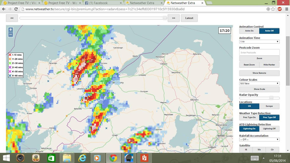 |
I arrived back home, I didn't bother with food, then got back online to check the latest, it was just after 17.00 then I spotted this post from convective forecaster Rory Icwp on facebook with the above radar image, Rory wrote...
''Warning for Donegal and North Ireland. Organised storms hail/possible tornado. Lifting shortwave with very strong 700mb vorticity and good 0-3 km Helicity is developing a low cape/high shear outbreak of storms these cells are very organised and displaying supercell characteristics currently. cells moving northeast''
It seemed the cap had broke and strong storms had fired over Donegal and Tyrone, the southern cells were not sparking however the NW cells were very active and I was on the verge of leaving and heading to the north coast, I was chatting online about this idea with several chasers and the more I talked the more I wanted to go, Owen Anderson would be flying in the area and he said he could see the cells from the coast, I was so committed that I actually said that I was leaving, my plan was to get to Downhill beach or the mountain tops in the area and watch the storms to the NW hoping for evening lightning however something kept holding me back, I actually walked to my bedroom door with the intention of leaving then turned around and sat back down again at the laptop, my mind wanted to go however my instincts had stopped me, I just couldn't make myself leave, then after 15 min's of an internal battle with myself I decided that I wouldn't go because I would just be standing on a cold mountain with drizzle around me and flat grey clouds over me with no structure and it wasn't dark enough for any night lightning, it would be a miserable experience and with no dinner I saw it being a waste of time so I made the final decision and called it off, I got away from the laptop for 10 min's to relax.
It was almost 18.00 and on an impulse I checked online again and noticed I had a private message on facebook from Rory again and the contents of which spoke for themselves, attached was the latest radar image showing two strong cells over Co. Tyrone, one was near Omagh and the other approaching Cookstown, both were slow moving and extremely well organised with impressive radar signatures and were clearly very strong storms which could be capable of tornadoes, Rory simply said something along the lines of ''get on these now!''. The adrenaline hit once again and I wasted no time, I shut the computer off, grabbed a jacket then headed to the car meeting my Mother coming in through the door, she asked where I was going and I said Omagh area, then she asked if she could come along and I said no problem, however I said we need to leave RITE NOW!, I explained about the massive cell over Omagh and the other near Cookstown and that there was no time to waste, mum said she had no dinner yet and I said neither have I so we just forgot about eating and put our minds on chasing, I was rather chuffed that my mum wanted to come along while missing out on the luxury of dinner and a relaxed evening indoors so that was rather nice to see, I have took my mum chasing with me on and off for years since I learned how to drive so I guessed it was in her blood now and she knew as well as I did that exciting things can happen at any moment.
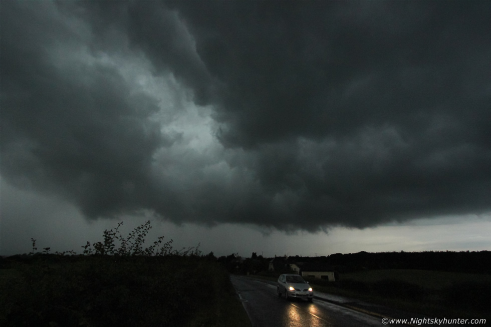
As I stood in the front yard I could feel how warm and humid the evening air was and how it certainly felt like storms were possible despite the flat sky, I couldn't see any hint of a storm in the sky to the SW at all and I was still debating over our target area, the Omagh cell was the largest however it was further away, the Cookstown cell was much closer and although smaller it was intensifying by the minute, both had large white cores on radar and just when I was struggling with the choice of target we heard a loud rumble of thunder from the SW in the direction of Cookstown, nature had made the decision for me, the Cookstown cell was now the target and it was probably closer now since the last radar update so we hit the road on the second storm chase of the day. We took the back roads and no matter where we looked there was no visual indication that there was a storm in the area, the sky looked flat and grey but we knew there was a beast out there somewhere and the assumption was it was an elevated storm, I just hoped we had made the correct decision on our choice of storm, we had a 50% chance of picking the rite one so we just had to stay optimistic and remain committed to our choice, this would turn out to be a very good decision.
 |
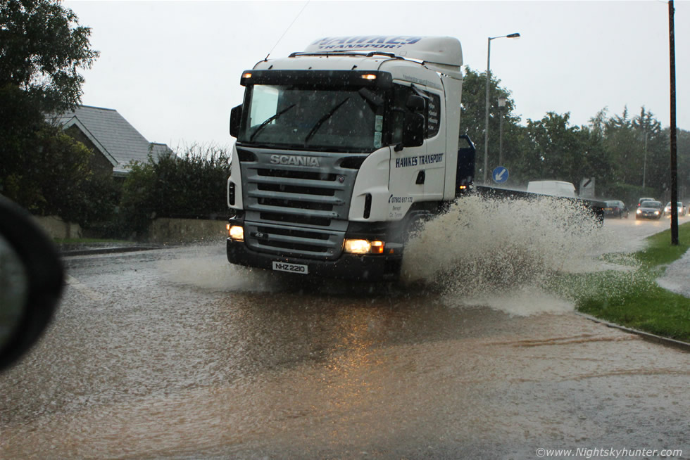
As soon as we approached the N side of Moneymore everything changed, the sky turned from grey to instantly dark then the rain began and we knew we where under the Tyrone storm, it felt like it had been camouflaged within the cloud and like a stealth bomber it struck out of nowhere. The rainfall was immediately intense, there was no build up, it just went from dry to intense rainfall like a switch had been flicked, we pulled over onto the hard shoulder just outside town to film the scene, visibility was terrible as rain hammered the road bouncing back up into the air, traffic appeared and disappeared from inside the precip curtains as if it had been a bank of fog, some drivers struggled in the conditions and we saw several cars pulling off the road because they simply couldn't see anything in front, there was even a cyclist caught out by the storm and I have to say I felt sorry for him as he was completely exposed to the elements and moving in the same direction the storm was so he would be under the core for a long time to come, you can get a glimpse of him at the start of the video.
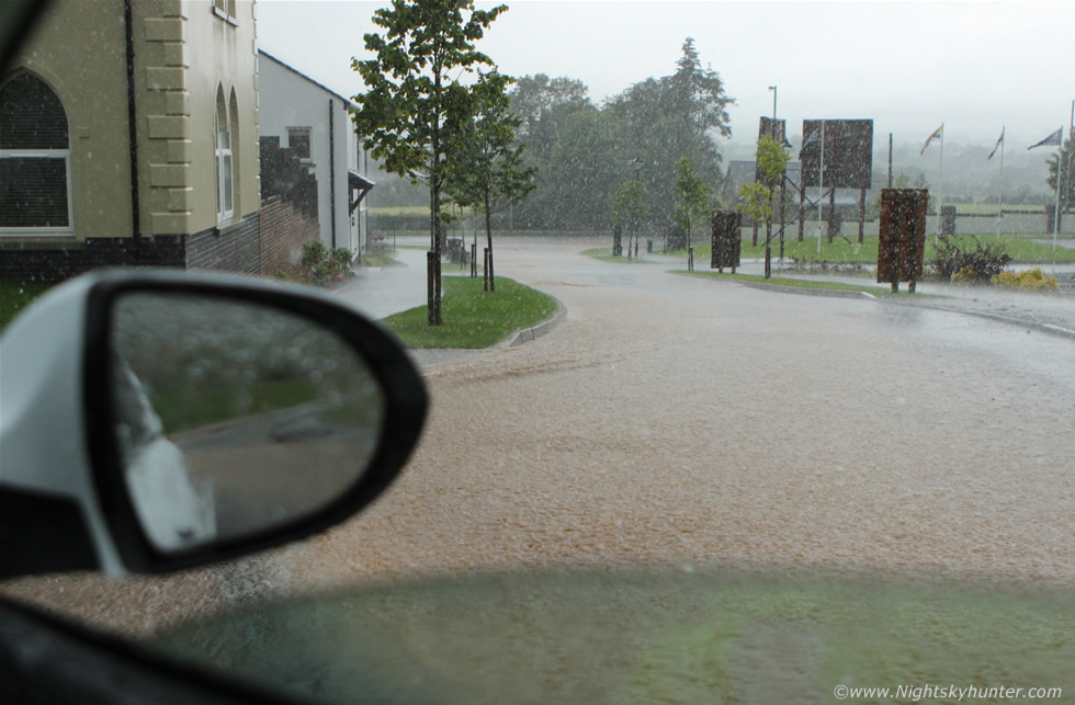
We got back on the road with wipers going like mad then just as we entered the top of the town we could see brown water flowing along the L side of the road like a torrent from a river, water gurgled and bubbled out from drains onto the road and several man hole covers had been displaced with water flowing out of them like an open wound in the road, it looked bad and it was obvious that traffic was getting affected and all this was happening with min's of the storm's arrival, it was clear where the source of the trouble was, at a junction to the main road was a road running downhill from a housing estate and it was from here where the rainfall was flowing, I knew in an instant this scene and the storm associated with it was already affecting people and would surely end up on the news. We drove up the steep road and parked near the top on the middle of the road in a new housing development called Gallion Heights and it was from here that a crazy event unfolded. I parked then put down the window and took images of the water as it flowed down the road meeting the main road at the bottom. Great sheets of torrential rain swept across the area drumming on the metallic roof of the car creating a loud non stop rumbling sound, the water turned brown in an instant and when I looked to the E I saw why, a grass embankment on high ground was getting washed down the road towards us with rainfall carrying mud and stones as one brown entity which was flowing faster and faster by the min and as it raced downhill it hit the traffic directly below us.
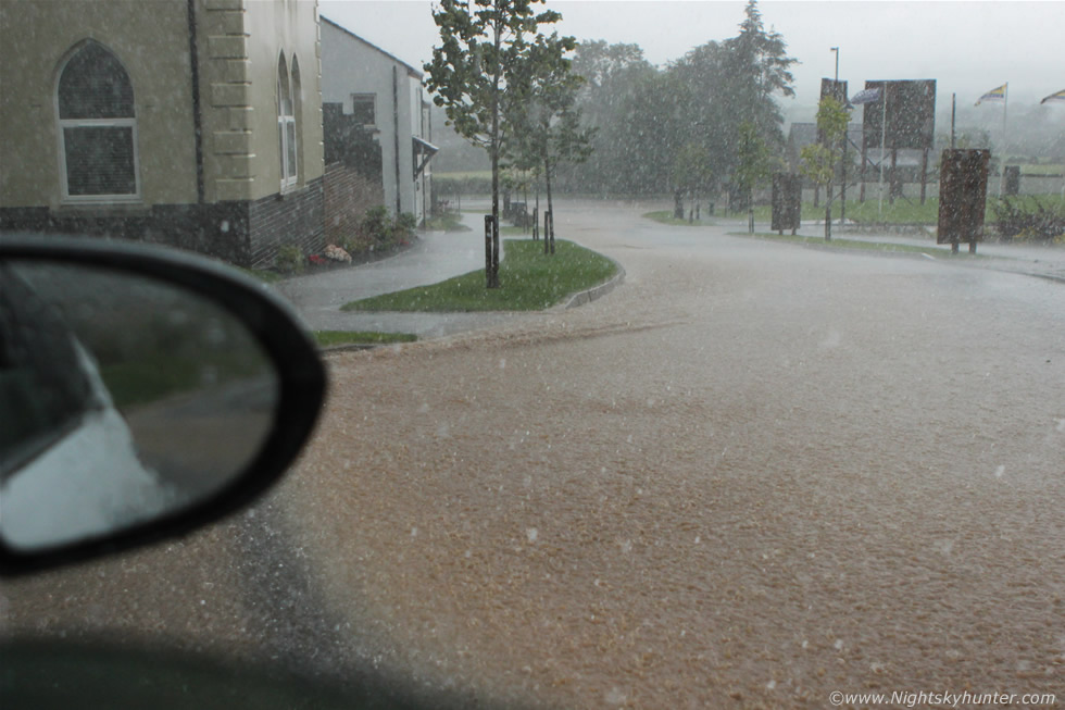 |
Massive raindrops fell from the sky large enough to be confused with hail stones at a glance, the rumbling downpour sent droplets to the earth so hard they bounced back off the road again and as we watched water churned and ran at a swift speed out from the drains and down the side of the road, it felt so weird parked here with brown water flowing under the car as surely as if we where parked on a shallow river with a strong current flowing under the chasis and around the wheels, mum and I were blown away by the sight and we realised we were in the middle of a significant high precipitation storm, the monsoon never stopped, it kept falling and falling with no end in sight then thunder cracked overhead and for the next 15-20 min's we sat here on our concrete river watching the insane rain with the thunder rumbling with greater frequency as the storm grew in strength. I was taking video using my Canon 600D with 24-70mm lens while mum was taking video from the other side of the car using the Samsung switch grip video camera and between the two of us we did a good job documenting the event. My phone went off, I answered, it was Paul Martin ringing from a 24 hour job in Coleraine otherwise we would have been out chasing together, he said that the rainfall in Omagh was mental with flooded streets and locals saying they had never experienced anything like it before in their lives, it seemed that both the Omagh and Moneymore cells were organised intense storms that were training and causing problems in both areas, it was good to hear from Paul and although he was at work he still had time to chat about the storm situation, that's passion for you!
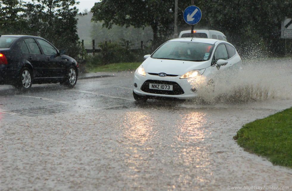 |
We drove to the bottom of the road and stopped at the junction in what seemed like a 'lake', I got away with staying here for a couple of min's shooting out the driver's window documenting traffic struggling through the flooded road while rain came in the open window soaking my camera, jeans and the inside of the car.
 |
This truck threw up a great brown wave as it passed which made for a fun moment of action photography, there was no end in sight, the rain kept coming and the water was getting deeper, I was tempted to park the car and get out on foot up the road and film the traffic from a different angle however things were getting crazy and it really was too wet for the camera, there was no question it would get destroyed so I stayed where I was for a few more video clips.
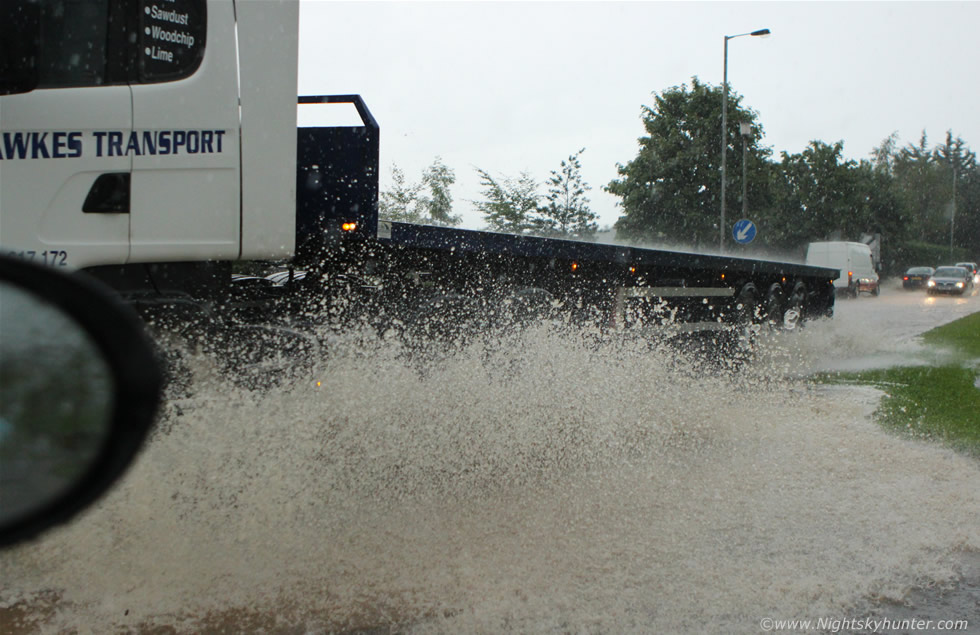 |
I should have wore a wet suit, check out the top of the trailer, you can see the rain bouncing off the surface which is pretty cool looking. The change in distance of the thunder indicated the storm was shifting to the N and E so I decided we should chase after it, this rainfall event alone made the entire day, it was spectacular to experience and even mum admitted she enjoyed it and that she had never seen anything like it before in her life, the storm badly effected Moneymore and Magherafelt where bad flooding occurred with minor damage to property, the fire brigade later arrived on the scene to help out, two people ended up being rescued from a house and car due to the flooding, although it was a thrill to be under nature when she is turning severe like this my heart still goes out to anyone who suffers a loss from property damage, a full week later there would still be stones and gravel on the road and significant damage to the tarmac on the roadside.
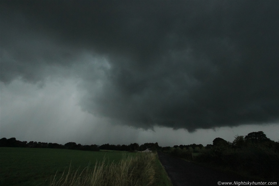
The storm was now a beast on radar with a large white core so we chased after it and punched the core yet again in Magherafelt, I needed to get a little more E to stay with the storm motion so I cut through the town at the main roundabout and we headed out to the back roads which lead to Ballyronan. As we drove through the country roads under torrential rain I didn't feel concerned about what would happen next, that rainfall event was the highlight of the storm so far so anything else would simply be the icing on the cake, I had to slow down to 20mph on the road as the rain and visibility was so bad, it was difficult to see and the road in places felt like driving through a shallow river, I never thought the storm would have any visible structure to shoot so I was shocked when suddenly I could see something through the sheets of rain to our half right, a big black something was discernable then we suddenly shot out from the core into dry air and good visibility - that was a shock in itself - we where ahead of the storm and on view was a massive black solid base taking up a large portion of the sky which was extremely impressive, if this storm was elevated it wasn't anymore, the base was fairly low down and extremely active with bizarre motion taking place.
We stopped at a lay by to watch then the sky got so spectacular that we both got out of the car to watch, a massive area of the base was rotating in a manner which I can only describe as stunning, big mean black clouds where spinning over the fields with large dark solid chunks swirling around, then the base rotated like a merry-go-round as it passed over the tops of the tall trees which lined the road where we had parked, I was astonished by what I was seeing, it honestly looked like it was going to put down a tornado at any moment!!!, while all this was happening thunder rumbled and c-g lightning struck the fields in the middle of the core which was off to the L. I got images of this rotation however they are not worth posting however I did have the presence of mind to set the video camera on the car roof using the mini tripod and filmed a portion of this event which shows up rather well on the video, I made three of these clips into a short time lapse which really shows how obvious the rotation was, but as always video never does justice to what the scene was like in person, hands down the best rotation I have seen in many years and nothing short of spectacular. Two horse and carts trotted past us on the country road, these were old fashioned open style carts with no roof, I thought they were crazy trotting down the road heading in the direction of the storm, did they not see the forecast?, did they not even know there was a storm happening rite now?, well ten min's later we met them again coming back from the direction of the storm, this time they were in full canter down the road and full retreat riding like mad men as they yelled and roared in a mad dash to get back to shelter, I reckon they came face to face with that core and saw those dangerous c-gs then immediately turned back and ran for their lives.
 |
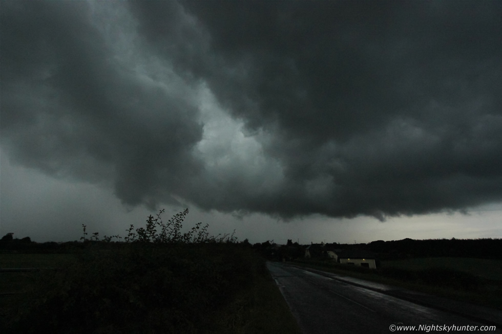
The core had reached us again and the blinding sheets of rain hid the base and its rotation from view so we moved on once more and raced ahead of the rain then arrived at Ballyronan Marina then took another country road opposite the marina which went in the direction of Magherafelt, we drove a mile down it then pulled over once the base got back in view again, the road was pointing directly towards the area of interest, I put the hazards on then went out for a few images. This was 10mm ultra wide angle showing the mean updraught base of this spectacular storm, note the organisation with precip vented to the L due to the massive tower far above leaning over with the wind shear aloft, the base to the R was rain free, solid, large and very well defined with plenty of rotation going on, the base was spinning away above the road and at times sudden wisps of scud would spin up from different locations along that base threatening a funnel or more. This being 10mm can you imagine how large that rotating updraught base was?, we were not the only observers watching this jaw dropping rotation, reports came in later from the surrounding area of locals saying they had never seen rotation like it before and ''unlikely to do so again'', there were reports of brief funnels and ''half funnels'' in the Ballyronan area.
I made very bad amateur mistakes photography-wise on this chase, I found that using my usual manual settings I couldn't get a good hand held image as the results were too dark so I simply used Av mode and left the ISO on auto and let the camera decide on what to choose and during quick glances at the LCD screen they seemed fine so I left it at that setting. My reason for this was that I had no time time to mess around getting the perfect manual setting for hand held shooting because there was simply no time to do so and most definitely no time to set up a tripod on a narrow country road, it was raining, dark, and infuriated drivers were giving me dirty looks for taking up the side of the road, even a large coach decided to take this same road with barely enough room to pass at all, he gave me some look I can tell you, but to heck with him, I see people pulled over dangerously on roads all the time to talk on a mobile phone so I felt justified enough just this once parking here to take a few images of a stunning storm. Combine all this road action with precip curtains catching up with you and you can see why it is not ideal for getting good images with a tripod, there was simply too much starting and stopping to be done in the car on this chase. Anyhow using Av was a major mistake, the camera by default chose a very high ISO of either 3200 or 6400 and as a result all my images are extremely noisy, the images on this report here have had significant noise reduction applied to them and they still look noisy, I also thought I was on auto focus however instead it was on manual so the scene is slightly out of focus, it's unreal that I could make these many photo mistakes during such a major storm, this is typical of what happens when you are out 'in the field', however despite all this I wanted to show several images anyway to help explain things. I will upgrade to a faster lens when I can, I have my eye on the Tokina 11-14mm F/2.8 which would be great for wide angle low light storm work as well as night sky photography.
 |
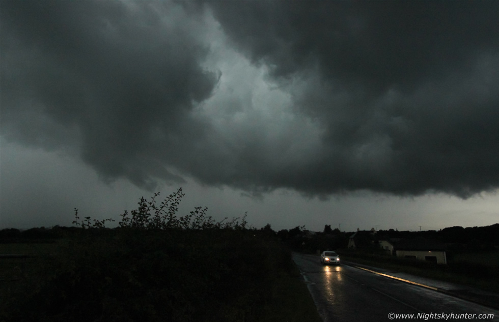
We were mobile once again in pursuit of the storm, the strategy was simple, stay ahead of the core and maintain a visual on the rotating base, we changed position, drove back to the Marina and took the road which runs adjacent to the lough and stopped somewhere between Ballyronan and Toome, I'm not sure exactly where this was however I recall a small bus shelter beside us, this was 10mm once again looking straight ahead at that stunning updraught base which was still rotating, the base from above the road to the top of this frame was one huge black rounded feature with rotating elements and a feature wrapping up to the L above the hedge, note the large clear slot in the base which looks a little like a rear flank downdraught or RFD feature often seen in the bases of supercells, I'm not saying it is RFD however it was an interesting feature none the less coinciding as it did with that rounded lowering.
 |
Wrapped up featuring now rotating and dragging strips of cloud around with it from R to L with big clear slot above, I was in heaven watching this.
 |
Lightning flickered within the precip behind it and to the L and thunder rumbled, scud could be seen getting sucked rapidly upward into the base indicating strong inflow, that area was near Toome so we moved on in that direction.
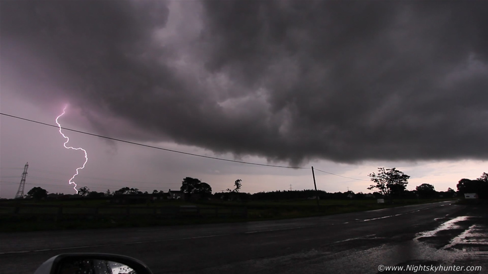 |
Now outside Toome, the storm had lost its rotation and was more of a big outflow dominant beast with a more linear appearance to the base. Mum was filming out the windscreen with the Samsung while I was filming from the driver's side window with the Canon and 10mm lens attached, I ended up catching this stunning c-g striking down in the fields, the brief flash of pink colour on the precip and cloud base was beautiful, this is 10mm remember so the actual bolt was much closer than it appears here, mum captured the same bolt on video too which was a nice moment, the storm was producing a lot of sferics however many of the bolts were buried in rain or i-c in nature so this c-g was a very lucky catch indeed. The big pylon in the distance marks the location of Toome line so that c-g must have been near the road, it would have made for a breathtaking image if caught in the same frame as the famous Toome Bridge, what an image that would have been.
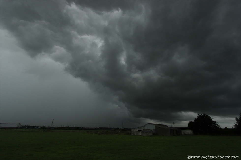 |
Stopped again at another location near Toome with the carriageway located on the other side of those pylons. The storm was absolutely massive, this is the Toome side of the monster gust front at 10mm, this stretched across the sky for another two frames of the 10mm lens to get in the W side. Pink lightning flashed here and over my L shoulder, check out the huge wall of silver torrential rain and hail - a nasty storm indeed.
For the last time we made another change of location and parked at the side of the carriageway on the Toome line where towering pylons and overhead wires dominated the sky, mum made a brew from a flask while I documented the storm, a stunning c-g struck down behind the pylons and more pink i-c flashes strobed within the rain to my L, I set the video camera on the roof and filmed the sky not really knowing where to aim as everywhere was producing random bolts. This time I attached the camera to the tripod and took many images with a longer exposure on continuous shooting hoping to catch a bolt, we must have spent 40 min's on the road side here, I didn't catch any more bolts despite the irregular flashes and rumbles however the visual experience was fantastic, the sky was mean as hell over the wires with rotation and out W over the fields was the flanking line of the storm which looked dark blue in the dusk sky, cloud hid much of the structure however during glimpses in the cloud I could see huge towers leaning over and back-building of very solid profile, the separation between updraught and downdraught once again reminded me of the side profile of a supercell storm, I just wished the visibility had been better.
My phone rang once again, it was my Dad, he was located on the top of Slieve Gallion, he had actually gone storm chasing himself which I thought was awesome!, as we spoke a long horizontal pink bolt whipped through the rain filling the field of the driver's window and I yelled ''lightning'', turned out Dad had witnessed the very same bolt from the mountain top, now that was a nice memory. We arrived home at 22.00, we had been chasing this storm for four hours!, it was without question the strongest thunderstorm in N. Ireland this year to date and it made quite an impression on those who watched it and as I expected - this storm and the Omagh and Donegal storms made it onto the news, in fact, BBC Newsline even used my video footage of the Moneymore flooding and Toome lightning on the main evening news including my images on the weather forecast which was a very nice treat after such long hours spent chasing. I enjoyed this storm immensely, aside from the photography flaws I did get some good segments of video and the visual and emotional experience alone was fantastic, every decision made was perfect and the positioning was text book, we got to sample the core and watch the remarkable rotation along with an abundance of lightning and all within my home area, it doesn't get much better than that.
HD Video footage of the chase featuring the Moneymore rainfall and flooding, the Ballyronan rotation and the Toome lightning with time lapse segments, also check out the dusk flanking area of the cell with possible wall cloud and tail cloud and the pylons near Toome with lights going on and off as the power flickered during the storm. If you have managed to read this report all the way through then I thank you for taking time out to do so, there is a alot of reading in it and it took alot of time to write so I thank you once again and I hope you enjoyed it - until the next chase.
Martin McKenna